

Forecast track

The official forecast track, drawn by this site from CPHC’s Advisory 10 (). Not an official CPHC product. Data: NOAA/NHC. CPHC’s own.
Current advisory context · Tropical Storm 46 mph (40 kt) · 1002 hPa · W at 8 mph (7 kt)
CPHC Advisory 10 ·
Latest advisory
Observed imagery loads separately from the advisory. The base map is not observed satellite imagery.
The cone describes center uncertainty; impacts can extend outside it.
Basemap
MaverickWX map · Data: NOAA/NHC · not an official graphic
Recorded weather · gaps are marked. Coverage begins with recording activation.
Live sources keep independent clocks.
Rolling target: 24 hours; cells: six hours. Radar: NOAA MRMS national overview, 8-minute tolerance. Satellite: original GOES GeoColor day/night picture, hourly sampling, 75-minute tolerance. No interpolation or latest-image fallback. Warning and source checks retain their own clocks. “Recorded by” is collector acquisition evidence, not exact browser publication history.
Current GLM density, velocity and specialist layers are hidden during replay. Snow uses retained footprint metadata with unverified pixel time. Forecast uses one pinned issuance/run and exact valid time.
No observed replay frame displayed.
Open the complete replay reader (works without scripting or WebGL)Choose Forecast for a pinned issuance and valid time.
No product matches. Try a hazard or source name.
Current cached context, independently dated. Regional products keep their published footprint; they are not clipped or attributed to one storm. This section remains separate from the historical replay cursor and official cyclone forecast. Use Forecast to pin a retained model package.
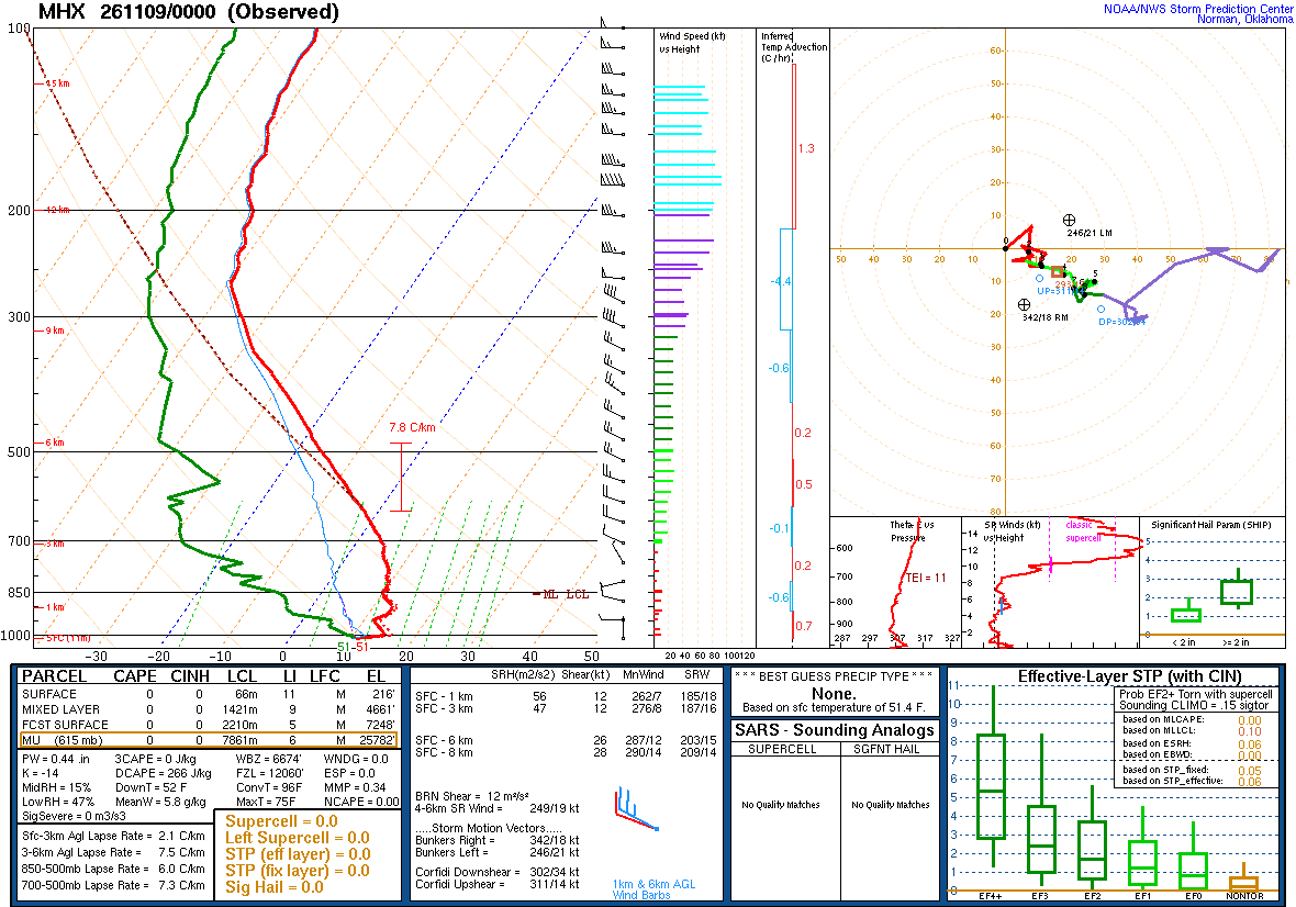
A balloon launched about an hour before the time named, measuring as it rose and drifted with the wind: the atmosphere above one place, at one time. Model soundings, which are forecasts, are not shown here.
| Pressure | Height | Temperature | Dew point | Wind |
|---|---|---|---|---|
| 1015 mb | 11 m | 10.8 | 10.3 | calm |
| 1002 mb | 123 m | 15.2 | 10.2 | — |
| 1000 mb | 140 m | 15.2 | 9.2 | 230° 11 kt |
| 981 mb | 305 m | 14.0 | 6.9 | 230° 10 kt |
| 967 mb | 423 m | 13.2 | 5.2 | — |
| 952 mb | 555 m | 12.2 | 5.2 | — |
| 925 mb | 796 m | 13.2 | -1.8 | 305° 9 kt |
| 912 mb | 914 m | 13.3 | -2.9 | 295° 12 kt |
| 896 mb | 1063 m | 13.2 | -3.8 | — |
| 879 mb | 1219 m | 11.9 | -4.6 | 285° 11 kt |
| 851 mb | 1493 m | 10.0 | -7.0 | — |
| 850 mb | 1503 m | 10.0 | -7.0 | 275° 13 kt |
| 822 mb | 1781 m | 10.0 | -14.0 | — |
| 803 mb | 1975 m | 8.8 | -11.2 | — |
| 788 mb | 2134 m | 8.7 | -17.2 | 285° 9 kt |
| 776 mb | 2257 m | 8.2 | -18.8 | — |
| 762 mb | 2407 m | 7.2 | -15.8 | — |
| 738 mb | 2669 m | 5.8 | -22.2 | — |
| 712 mb | 2962 m | 5.0 | -27.0 | — |
| 700 mb | 3100 m | 3.8 | -28.2 | 295° 12 kt |
| 686 mb | 3264 m | 3.0 | -29.0 | — |
| 653 mb | 3658 m | 0.2 | -30.5 | 290° 18 kt |
| 636 mb | 3872 m | -1.3 | -31.3 | — |
| 615 mb | 4139 m | -3.1 | -34.1 | — |
| 605 mb | 4268 m | -4.1 | -32.1 | — |
| 594 mb | 4413 m | -5.3 | -35.3 | — |
| 582 mb | 4572 m | -6.5 | -32.8 | 300° 25 kt |
| 562 mb | 4845 m | -8.5 | -28.5 | — |
| 538 mb | 5182 m | -11.2 | -32.4 | 290° 30 kt |
| 517 mb | 5486 m | -13.6 | -35.9 | 300° 25 kt |
| 500 mb | 5740 m | -15.5 | -38.5 | 290° 27 kt |
| 480 mb | 6046 m | -18.1 | -43.1 | — |
| 462 mb | 6330 m | -19.9 | -43.9 | — |
| 439 mb | 6706 m | -22.8 | -45.0 | 300° 27 kt |
| 421 mb | 7010 m | -25.1 | -45.8 | 300° 24 kt |
| 400 mb | 7380 m | -27.9 | -46.9 | 305° 27 kt |
| 387 mb | 7620 m | -30.1 | -47.5 | 305° 28 kt |
| 371 mb | 7914 m | -32.5 | -50.5 | — |
| 355 mb | 8230 m | -35.4 | -51.3 | 300° 28 kt |
| 340 mb | 8521 m | -38.1 | -52.1 | — |
| 324 mb | 8839 m | -40.3 | -54.6 | 295° 33 kt |
| 310 mb | 9144 m | -42.1 | -56.9 | 295° 44 kt |
| 300 mb | 9370 m | -43.7 | -58.7 | 300° 45 kt |
| 283 mb | 9754 m | -46.2 | -60.3 | 300° 43 kt |
| 271 mb | 10058 m | -48.2 | -61.5 | 295° 40 kt |
| 260 mb | 10322 m | -49.3 | -63.3 | — |
| 250 mb | 10580 m | -49.7 | -62.7 | 270° 68 kt |
| 239 mb | 10873 m | -51.1 | -64.1 | — |
| 228 mb | 11178 m | -51.3 | -64.3 | — |
| 218 mb | 11467 m | -52.7 | -65.7 | — |
| 200 mb | 12020 m | -53.9 | -66.9 | 265° 82 kt |
| 190 mb | 12347 m | -56.1 | -69.1 | — |
| 177 mb | 12802 m | -57.8 | -70.8 | 270° 93 kt |
| 161 mb | 13388 m | -58.3 | -72.3 | — |
| 150 mb | 13830 m | -60.1 | -73.1 | 275° 67 kt |
| 140 mb | 14259 m | -61.3 | -74.3 | — |
| 129 mb | 14765 m | -62.7 | -75.7 | 275° 67 kt |
| 114 mb | 15545 m | -63.5 | -76.5 | 280° 64 kt |
| 103 mb | 16154 m | -63.7 | -76.7 | 265° 48 kt |
| 100 mb | 16330 m | -64.3 | -77.3 | 270° 48 kt |
SPC observed soundings checked · Data: NOAA/SPC
CPHC Advisory 10 · advisory · forecast cycle . Forecast positions are future estimates, not observed imagery. Classification is shown only where published.
| Valid time / lead | Position | Classification | Sustained wind |
|---|---|---|---|
+0 h from forecast cycle | 11.4°N, 157.2°W | Tropical storm | 46 mph (40 kt) |
+3 h from forecast cycle | 11.4°N, 157.6°W | Tropical storm | 46 mph (40 kt) |
+12 h from forecast cycle | 11.4°N, 159.2°W | Tropical storm | 46 mph (40 kt) |
+24 h from forecast cycle | 11.3°N, 161.5°W | Tropical storm | 46 mph (40 kt) |
+36 h from forecast cycle | 11.3°N, 163.5°W | Tropical storm | 46 mph (40 kt) |
+48 h from forecast cycle | 11.2°N, 165.6°W | Tropical storm | 52 mph (45 kt) |
+60 h from forecast cycle | 11.1°N, 168.0°W | Tropical storm | 52 mph (45 kt) |
+72 h from forecast cycle | 11.3°N, 170.9°W | Tropical storm | 52 mph (45 kt) |
+96 h from forecast cycle | 12.6°N, 177.1°W | Tropical storm | 46 mph (40 kt) |
+120 h from forecast cycle | 14.4°N, 177.2°E | Tropical storm | 46 mph (40 kt) |
Each entry selects one immutable snapshot. Intermediate, special and corrected records are separate identities where retained. Current NWS context is labelled separately. Historical impact manifests are not retained by this index; newer impacts are never attached to an earlier advisory. Same-time corrections replaced in the publisher’s index cannot be selected unless still listed.
| Official issuance | Revision kind | Record |
|---|---|---|
| CPHC Advisory 10 · | advisory | Snapshot 0bcae4ab · Selected |
| CPHC Unnumbered state · | advisory | Snapshot d9b6706d |
| CPHC Advisory 9 · | advisory | Snapshot 23b015f2 |
| CPHC Unnumbered state · | advisory | Snapshot 7081a2c1 |
| CPHC Advisory 8 · | advisory | Snapshot 9cccd530 |
| CPHC Unnumbered state · | advisory | Snapshot 72fa3e5c |
| CPHC Advisory 7 · | advisory | Snapshot 9d4bd068 |
| CPHC Unnumbered state · | advisory | Snapshot 34f11ed6 |
| CPHC Advisory 6 · | advisory | Snapshot 7b6af387 |
| CPHC Unnumbered state · | advisory | Snapshot feb3dd6a |
| CPHC Advisory 5 · | advisory | Snapshot 056a0eb5 |
| CPHC Unnumbered state · | advisory | Snapshot e296178e |
| CPHC Advisory 4 · | advisory | Snapshot 8e23913e |
| CPHC Unnumbered state · | advisory | Snapshot 9ce314ee |
| CPHC Advisory 3 · | advisory | Snapshot f167fe92 |
| CPHC Unnumbered state · | advisory | Snapshot b161830f |
| CPHC Advisory 2 · | advisory | Snapshot 6eb780c9 |
| CPHC Unnumbered state · | advisory | Snapshot c16d8efc |
| CPHC Advisory 1 · | first | Snapshot 5be09be7 |
The storm’s area, by its warning centre’s products: everything listed is in force in this area, never “from this storm”.
The official forecast track, drawn by this site from CPHC’s Advisory 10 (). Not an official CPHC product. Data: NOAA/NHC. CPHC’s own.
| Place | 34 kt | 50 kt | 64 kt |
|---|---|---|---|
| 10n 170w | 6% | — | — |
| 10n 165w | 5% | — | — |
NHC’s chance of sustained wind of at least each speed at each place it lists, through ; the places with the highest chance of 34 kt first. Issued . Data: NOAA/NHC. NHC’s table.
NHC has no coastal watch or warning in effect for this storm.
In NHC’s words, Advisory 10, issued . The areas NHC names, in the United States and abroad; for a place outside the United States its national service is the warning authority. Data: NOAA/NHC. NHC’s advisory.

The official intensity forecast, drawn by this site from CPHC’s Advisory 10 (). Not an official CPHC product. Data: NOAA/NHC. CPHC’s own.
The storm’s page shows it on NASA GIBS (NOAA GOES, JMA Himawari)’s imagery, loaded by your browser. GOES-West at 20° from the storm's meridian.
Imagery from NASA GIBS: NOAA GOES and JMA Himawari.

The models’ tracks, which are not a forecast, drawn by this site from CPHC’s Advisory 10 (). Not an official CPHC product. Data: NOAA/NHC. CPHC’s own.
NOAA’s radar for the area, loaded by your browser as on the Radar page.
Drawn live: if the radar fails, nothing older is shown in its place.
Saved places are read from this device after scripting starts.
Search stays in this browser. A town point is not an address; no address-level surge is calculated.