

STORM MODEWeather tracking workspace
Agency warning geometry · no observed imagery displayed
Map
NWS’s polygons as issued, or the zones a zone-issued alert names; SPC’s watches by their counties. Checked . Data: NOAA/NWS, NOAA/SPC.
ⓘ About this map
Outlines: NOAA/NWS · Radar cells: IEM/NEXRAD. Outlines are warned areas, not storm paths.
Keys: R radar · V velocity · S satellite · O off · F fit area · L layers
Interactive imagery loads separately. Missing radar does not remove warnings or imply clear weather.
Recorded weather · gaps are marked. Coverage begins with recording activation.
Live sources keep independent clocks.
Replay coverage and interpretation
Rolling target: 24 hours; cells: six hours. Radar: NOAA MRMS national overview, 8-minute tolerance. Satellite: original GOES GeoColor day/night picture, hourly sampling, 75-minute tolerance. No interpolation or latest-image fallback. Warning and source checks retain their own clocks. “Recorded by” is collector acquisition evidence, not exact browser publication history.
Current GLM density, velocity and specialist layers are hidden during replay. Snow uses retained footprint metadata with unverified pixel time. Forecast uses one pinned issuance/run and exact valid time.
No observed replay frame displayed.
Open the complete replay reader (works without scripting or WebGL)Analysis and guidance
Choose product
Current weather
ReportsAnalysis and guidanceRadarObservations
Coastal observationsRadar-derived cellsStations and river gaugesSevere storms
SPC Day 1 outlookWatchesMesoscale discussionsRain and flooding
Flash-flood risk, Day 1River gauges in floodRain expected and rain that fellNo product matches. Try a hazard or source name.
Analysis
Area, source times and interpretation
Current cached context, independently dated. Regional reference: TX; a reference within a wider monitoring area does not replace the complete warning geography. This section remains separate from the historical replay cursor and official cyclone forecast. Use Forecast to pin a retained model package.
Soundings: what weather balloons measured
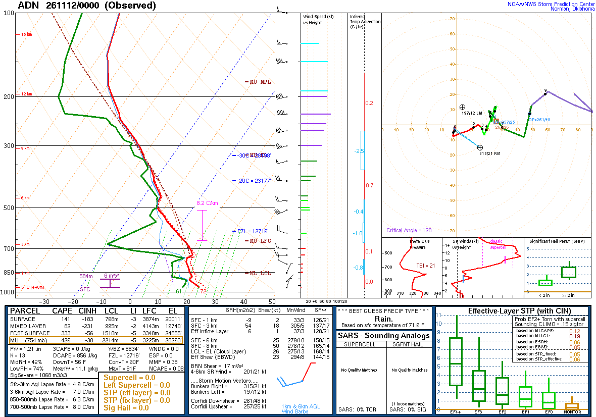
A balloon launched about an hour before the time named, measuring as it rose and drifted with the wind: the atmosphere above one place, at one time. Model soundings, which are forecasts, are not shown here.
The levels this sounding was drawn from (36)
| Pressure | Height | Temperature | Dew point | Wind |
|---|---|---|---|---|
| 965 mb | 448 m | 22.0 | 16.0 | 020° 4 kt |
| 925 mb | 815 m | 18.4 | 16.1 | 065° 2 kt |
| 902 mb | 1032 m | 16.4 | 15.2 | — |
| 883 mb | 1215 m | 16.8 | 9.8 | — |
| 854 mb | 1501 m | 15.1 | 8.9 | 025° 6 kt |
| 850 mb | 1541 m | 14.8 | 8.8 | 020° 8 kt |
| 824 mb | 1803 m | 13.5 | 7.8 | 350° 6 kt |
| 795 mb | 2104 m | 11.9 | 6.7 | 300° 8 kt |
| 782 mb | 2243 m | 11.2 | 6.2 | — |
| 754 mb | 2548 m | 10.4 | 9.5 | — |
| 740 mb | 2705 m | 11.6 | 4.6 | 270° 14 kt |
| 713 mb | 3014 m | 10.0 | -10.0 | — |
| 700 mb | 3167 m | 9.2 | -13.8 | 275° 16 kt |
| 673 mb | 3492 m | 7.0 | -21.0 | — |
| 617 mb | 4191 m | 1.1 | -15.4 | 290° 19 kt |
| 561 mb | 4956 m | -5.3 | -9.3 | — |
| 533 mb | 5357 m | -8.1 | -13.0 | — |
| 510 mb | 5698 m | -11.2 | -13.3 | 245° 29 kt |
| 500 mb | 5850 m | -12.3 | -12.5 | 245° 27 kt |
| 478 mb | 6192 m | -13.7 | -13.8 | — |
| 456 mb | 6549 m | -13.7 | -15.1 | — |
| 400 mb | 7530 m | -20.1 | -23.2 | 275° 31 kt |
| 386 mb | 7794 m | -21.3 | -25.6 | 280° 45 kt |
| 361 mb | 8286 m | -24.3 | -25.2 | — |
| 341 mb | 8698 m | -27.8 | -28.3 | 255° 51 kt |
| 324 mb | 9066 m | -30.1 | -33.3 | — |
| 300 mb | 9610 m | -33.9 | -37.1 | 250° 64 kt |
| 286 mb | 9943 m | -36.5 | -40.6 | — |
| 264 mb | 10491 m | -41.5 | -45.3 | 255° 70 kt |
| 250 mb | 10860 m | -44.7 | -49.3 | 260° 78 kt |
| 239 mb | 11160 m | -47.3 | -52.3 | — |
| 200 mb | 12320 m | -55.3 | -74.3 | 255° 80 kt |
| 182 mb | 12916 m | -59.7 | -75.7 | — |
| 150 mb | 14110 m | -65.5 | -80.5 | 260° 82 kt |
| 129 mb | 15007 m | -69.1 | -82.9 | 265° 56 kt |
| 100 mb | 16510 m | -73.5 | -86.5 | 280° 51 kt |
Every station with a sounding (76)
- Aberdeen, SD (ABR)
- ADN
- Albany, NY (ALB)
- Albuquerque, NM (ABQ)
- Amarillo, TX (AMA)
- Birmingham, AL (BMX)
- Bismarck, ND (BIS)
- Blacksburg, VA (RNK)
- Boise, ID (BOI)
- Brownsville, TX (BRO)
- Buffalo, NY (BUF)
- Cape Canaveral, FL (XMR)
- Caribou, ME (CAR)
- Chanhassen, MN (MPX)
- Charleston, SC (CHS)
- Chihuahua, Mexico (76225)
- Corpus Christi, TX (CRP)
- Davenport, IA (DVN)
- Del Rio, TX (DRT)
- Dodge City, KS (DDC)
- Elko, NV (LKN)
- Flagstaff, AZ (FGZ)
- Fort Worth, TX (FWD)
- Gaylord, MI (APX)
- Glasgow, MT (GGW)
- Grand Junction, CO (GJT)
- Gray, ME (GYX)
- GRB
- Great Falls, MT (TFX)
- Greensboro, NC (GSO)
- International Falls, MN (INL)
- Jackson, MS (JAN)
- Jacksonville, FL (JAX)
- Key West, FL (KEY)
- La Paz, Mexico (76405)
- Lake Charles, LA (LCH)
- Lamont, OK (LMN)
- Las Vegas, NV (VEF)
- Lincoln, IL (ILX)
- Little Rock, AR (LZK)
- Maniwaki, Quebec (WMW)
- Mazatlán, Mexico (76458)
- Medford, OR (MFR)
- Miami, FL (MFL)
- Midland, TX (MAF)
- Nashville, TN (BNA)
- Newport, NC (MHX)
- Norman, OK (OUN)
- North Platte, NE (LBF)
- Oakland, CA (OAK)
- OYU
- Peachtree City, GA (FFC)
- Pickle Lake, Ontario (WPL)
- Pittsburgh, PA (PIT)
- Quillayute, WA (UIL)
- Rapid City, SD (UNR)
- Reno, NV (REV)
- Riverton, WY (RIW)
- Salem, OR (SLE)
- Salt Lake City, UT (SLC)
- San Diego, CA (NKX)
- Santa Teresa, NM (EPZ)
- Shreveport, LA (SHV)
- Slidell, LA (LIX)
- Spokane, WA (OTX)
- Springfield, MO (SGF)
- Sterling, VA (IAD)
- Tampa Bay, FL (TBW)
- Topeka, KS (TOP)
- Upton, NY (OKX)
- Valley, NE (OAX)
- Vandenberg, CA (VBG)
- White Lake, MI (DTX)
- Wilmington, OH (ILN)
- Yarmouth, Nova Scotia (YQI)
- Zacatecas, Mexico (76526)
SPC observed soundings checked · Data: NOAA/SPC
Radar-derived cells (0) · current
Collector checked ; feed generated . Zero cells does not establish coverage or clear weather. Observations from different radars are not merged.
Station and river observations (153)
Surface source current; observed water-level source current. Each reading keeps its own time. Map markers show at most 500 stations and 500 gauges; the complete source directory is paginated.
Circle: surface station; square: water-level gauge. Filled: current reading and source; hollow: stale, unconfirmed or missing observation. Marker color is not a hazard category. Enable “Stations and gauges” in Layers to inspect them on the map.
- K0F2 · Surface station K0F2 · 47 °F (8.5 °C) · wind 0 kt · current ·
- K11R · Surface station K11R · 61 °F (16 °C) · wind 6 kt · current ·
- K2R9 · Surface station K2R9 · 59 °F (15 °C) · wind 3 kt · weather BR · current ·
- K4F2 · Surface station K4F2 · 56 °F (13.5 °C) · wind 5 kt · current ·
- K5C1 · Surface station K5C1 · 55 °F (13 °C) · wind 3 kt · current ·
- K5T9 · Surface station K5T9 · 57 °F (14 °C) · wind 5 kt · weather BR · current ·
- K66R · Surface station K66R · 60 °F (15.4 °C) · wind 0 kt · weather BR · current ·
- K6P9 · Surface station K6P9 · 47 °F (8.6 °C) · wind 4 kt · current ·
- K6R3 · Surface station K6R3 · 59 °F (15.2 °C) · wind 0 kt · current ·
- K81R · Surface station K81R · 51 °F (10.6 °C) · wind 4 kt · current ·
- K8T6 · Surface station K8T6 · 59 °F (15 °C) · wind 0 kt · weather BR · current ·
- KACT · Surface station KACT · 53 °F (11.7 °C) · wind 4 kt · current ·
- KADS · Surface station KADS · 57 °F (14 °C) · wind 0 kt · current ·
- KAFW · Surface station KAFW · 54 °F (12.2 °C) · wind 7 kt · current ·
- KALI · Surface station KALI · 63 °F (17.2 °C) · wind 7 kt · current ·
- KAMA · Surface station KAMA · 43 °F (6.1 °C) · wind 6 kt · current ·
- KAPY · Surface station KAPY · 62 °F (16.6 °C) · wind 0 kt · current ·
- KAQO · Surface station KAQO · 54 °F (12 °C) · wind 0 kt · current ·
- KARM · Surface station KARM · 61 °F (16.2 °C) · wind 4 kt · current ·
- KAUS · Surface station KAUS · 62 °F (16.7 °C) · wind 7 kt · current ·
- KAXH · Surface station KAXH · 62 °F (16.5 °C) · wind 3 kt · current ·
- KBAZ · Surface station KBAZ · 59 °F (15 °C) · wind 0 kt · current ·
- KBBD · Surface station KBBD · 52 °F (11 °C) · wind 7 kt · current ·
- KBEA · Surface station KBEA · 62 °F (16.5 °C) · wind 5 kt · current ·
- KBGD · Surface station KBGD · 45 °F (7.2 °C) · wind 5 kt · current ·
- KBKD · Surface station KBKD · wind 0 kt · current ·
- KBMQ · Surface station KBMQ · 59 °F (15 °C) · wind 5 kt · current ·
- KBMT · Surface station KBMT · 59 °F (14.9 °C) · wind 4 kt · current ·
- KBPG · Surface station KBPG · 50 °F (9.9 °C) · wind 0 kt · current ·
- KBPT · Surface station KBPT · 59 °F (15 °C) · wind 5 kt · weather BR · current ·
- KCDS · Surface station KCDS · 47 °F (8.3 °C) · wind 6 kt · weather HZ · current ·
- KCFD · Surface station KCFD · 59 °F (14.9 °C) · wind 4 kt · current ·
- KCNW · Surface station KCNW · 52 °F (11 °C) · wind 3 kt · current ·
- KCOM · Surface station KCOM · 50 °F (10 °C) · wind 3 kt · current ·
- KCOT · Surface station KCOT · 59 °F (15 °C) · wind 4 kt · weather BR · current ·
- KCRP · Surface station KCRP · 63 °F (17.2 °C) · wind 6 kt · current ·
- KCRS · Surface station KCRS · 56 °F (13.3 °C) · wind 4 kt · current ·
- KCVB · Surface station KCVB · 57 °F (14 °C) · wind 6 kt · current ·
- KCWC · Surface station KCWC · 51 °F (10.7 °C) · current ·
- KCZT · Surface station KCZT · 57 °F (14 °C) · wind 3 kt · current ·
- KDAL · Surface station KDAL · 54 °F (12.2 °C) · wind 0 kt · current ·
- KDHT · Surface station KDHT · 39 °F (3.9 °C) · wind 6 kt · weather HZ · current ·
- KDRT · Surface station KDRT · 57 °F (13.9 °C) · wind 4 kt · weather BR · current ·
- KDTO · Surface station KDTO · 50 °F (10 °C) · wind 3 kt · current ·
- KDUX · Surface station KDUX · 41 °F (5 °C) · wind 10 kt · current ·
- KDYS · Surface station KDYS · 51 °F (10.5 °C) · wind 4 kt · current ·
- KDZB · Surface station KDZB · 56 °F (13.5 °C) · wind 0 kt · current ·
- KE01 · Surface station KE01 · 50 °F (10 °C) · wind 0 kt · current ·
- KE11 · Surface station KE11 · 47 °F (8.5 °C) · wind 0 kt · current ·
- KE35 · Surface station KE35 · 46 °F (7.8 °C) · wind 0 kt · current ·
- KE38 · Surface station KE38 · 41 °F (5.1 °C) · wind 6 kt · current ·
- KE41 · Surface station KE41 · 52 °F (10.9 °C) · wind 6 kt · current ·
- KE42 · Surface station KE42 · 43 °F (5.9 °C) · wind 7 kt · current ·
- KE57 · Surface station KE57 · 43 °F (6 °C) · wind 3 kt · current ·
- KEBG · Surface station KEBG · 64 °F (18 °C) · wind 5 kt · current ·
- KECU · Surface station KECU · 55 °F (13 °C) · wind 7 kt · current ·
- KEFD · Surface station KEFD · 63 °F (17 °C) · wind 0 kt · current ·
- KELA · Surface station KELA · 60 °F (15.7 °C) · wind 0 kt · weather BR · current ·
- KERV · Surface station KERV · 53 °F (11.9 °C) · wind 0 kt · current ·
- KETN · Surface station KETN · 41 °F (4.8 °C) · wind 0 kt · current ·
- KF00 · Surface station KF00 · 52 °F (11 °C) · wind 6 kt · current ·
- KF05 · Surface station KF05 · 49 °F (9.5 °C) · wind 0 kt · current ·
- KF44 · Surface station KF44 · 55 °F (13 °C) · wind 5 kt · current ·
- KF46 · Surface station KF46 · 54 °F (12.2 °C) · wind 3 kt · current ·
- KFTN · Surface station KFTN · 59 °F (15 °C) · wind 4 kt · weather BR · current ·
- KGDJ · Surface station KGDJ · 50 °F (10 °C) · wind 2 kt · current ·
- KGGG · Surface station KGGG · 53 °F (11.7 °C) · wind 3 kt · current ·
- KGKY · Surface station KGKY · 48 °F (8.9 °C) · wind 0 kt · current ·
- KGLE · Surface station KGLE · 50 °F (10.2 °C) · wind 4 kt · current ·
- KGLS · Surface station KGLS · 66 °F (18.9 °C) · wind 6 kt · current ·
- KGNC · Surface station KGNC · 46 °F (7.5 °C) · wind 0 kt · current ·
- KGOP · Surface station KGOP · 52 °F (11 °C) · wind 3 kt · current ·
- KGPM · Surface station KGPM · 59 °F (14.9 °C) · wind 0 kt · current ·
- KGRK · Surface station KGRK · 57 °F (13.8 °C) · wind 8 kt · current ·
- KGTU · Surface station KGTU · 58 °F (14.4 °C) · wind 4 kt · current ·
- KGVT · Surface station KGVT · 47 °F (8.3 °C) · wind 0 kt · current ·
- KGYB · Surface station KGYB · 60 °F (15.8 °C) · wind 5 kt · current ·
- KGZN · Surface station KGZN · 50 °F (10 °C) · wind 5 kt · current ·
- KHDO · Surface station KHDO · 54 °F (12.2 °C) · wind 4 kt · current ·
- KHHF · Surface station KHHF · 37 °F (3 °C) · wind 2 kt · current ·
- KHLR · Surface station KHLR · 56 °F (13.6 °C) · wind 4 kt · current ·
- KHQZ · Surface station KHQZ · 55 °F (12.6 °C) · wind 6 kt · current ·
- KHRL · Surface station KHRL · wind 6 kt · current ·
- KHRX · Surface station KHRX · 38 °F (3.2 °C) · wind 6 kt · current ·
- KIAH · Surface station KIAH · 62 °F (16.7 °C) · wind 7 kt · current ·
- KINJ · Surface station KINJ · 52 °F (11.1 °C) · wind 7 kt · current ·
- KJAS · Surface station KJAS · 54 °F (12 °C) · wind 0 kt · weather FG · current ·
- KJXI · Surface station KJXI · 55 °F (12.8 °C) · wind 0 kt · current ·
- KLBX · Surface station KLBX · 59 °F (15 °C) · wind 3 kt · weather BR · current ·
- KLHB · Surface station KLHB · 54 °F (12 °C) · wind 2 kt · current ·
- KLLN · Surface station KLLN · 41 °F (5 °C) · wind 6 kt · current ·
- KLRD · Surface station KLRD · 62 °F (16.7 °C) · wind 4 kt · current ·
- KLUD · Surface station KLUD · 57 °F (14 °C) · wind 5 kt · current ·
- KLUV · Surface station KLUV · 46 °F (8 °C) · wind 5 kt · current ·
- KLVJ · Surface station KLVJ · 63 °F (17.2 °C) · wind 0 kt · current ·
- KLXY · Surface station KLXY · 55 °F (12.9 °C) · wind 3 kt · current ·
- KLZZ · Surface station KLZZ · 55 °F (13 °C) · wind 5 kt · current ·
- KMDD · Surface station KMDD · 51 °F (10.4 °C) · wind 0 kt · current ·
- KMKN · Surface station KMKN · 53 °F (11.5 °C) · current ·
- KMNZ · Surface station KMNZ · 52 °F (11 °C) · wind 7 kt · current ·
Showing 100 of 153 listed sources. All surface stations and retained trends · All supported gauges and forecasts
About this monitored event
This event, as this site’s operators set it up
- Kind
- Severe weather
- Window
- Open: no start or end was set
- Updated
Spotlight
8 products · choose oneWatches
Mesoscale discussions
Storm ingredients
Flash-flood risk, Day 1
River gauges in flood
Rain expected and rain that fell
Radar
Monitoring area details
- Area
- Texas (NWS states: TX)
- Hazards
- Tornado, severe thunderstorm, flash flood, river flood, areal flood, coastal flood and other warnings, watches and advisories, and the forecasts for them
- Window
- In force now, with the next days of SPC’s and WPC’s products
- Made by
- This site’s operators, in its admin console. Nothing about a reader is stored. Watch another area
An area the operators chose, not a storm’s footprint: everything here is in force in this area, never “from this event”.
Alerts in this area
No warning, watch or advisory for these hazards is in force in this area.
NWS’s alerts checked : a successful check, so this is none in force, not “can’t tell”.
My places
Places saved on this device appear here with scripting enabled.
Alerts in this area
Area briefPeek viewNo alerts in Test123 ·